SOLDES
Jusqu'à -70% sur une sélection d'articles*

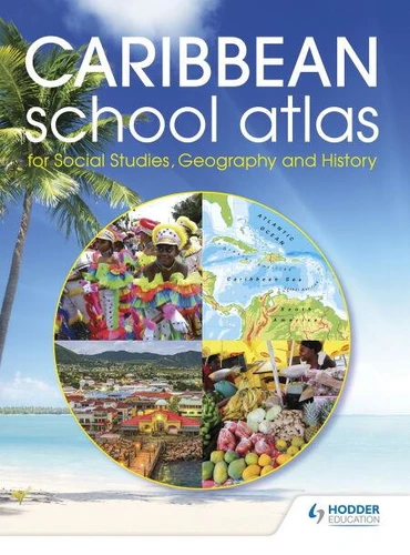
Hodder Education Caribbean School Atlas
Par :Formats :
Disponible dans votre compte client Decitre ou Furet du Nord dès validation de votre commande. Le format Epub fixed layout protégé est :
- Compatible avec une lecture sur My Vivlio (smartphone, tablette, ordinateur)
- Compatible avec une lecture sur liseuses Vivlio
- Pour les liseuses autres que Vivlio, vous devez utiliser le logiciel Adobe Digital Edition. Non compatible avec la lecture sur les liseuses Kindle, Remarkable et Sony
- Non compatible avec un achat hors France métropolitaine
Notre partenaire de plateforme de lecture numérique où vous retrouverez l'ensemble de vos ebooks gratuitement
Pour en savoir plus sur nos ebooks, consultez notre aide en ligne ici
C'est si simple ! Lisez votre ebook avec l'app Vivlio sur votre tablette, mobile ou ordinateur :

- Nombre de pages96
- FormatEpub fixed layout
- ISBN978-1-5104-3464-6
- EAN9781510434646
- Date de parution23/09/2018
- Protection num.Adobe DRM
- Infos supplémentairesepub
- ÉditeurHodder Education
Résumé
Feel confident in full coverage of the curriculum requirements with an atlas specially created to cover Social Studies, Geography and History. - Encourage awareness of the whole Caribbean region with a 44-page Caribbean section, containing detailed maps of all independent countries and major dependent territories from The Bahamas to Trinidad, and including Belize and Guyana.- Engage students in topical issues with a world mapping section, including features on world climate, the environment and population.
- Introduce a solid foundation in geographical knowledge with world facts and figures for all nations.- Secure strong geographical skills with a feature on map reading and how to use an atlas.- Ensure ease-of-use with a 4-page index showing letter-figure grid references to place names found on the maps.
- Introduce a solid foundation in geographical knowledge with world facts and figures for all nations.- Secure strong geographical skills with a feature on map reading and how to use an atlas.- Ensure ease-of-use with a 4-page index showing letter-figure grid references to place names found on the maps.
A propos de Hodder Education

26,99 €
26,99 €
26,99 €